


Table of Contents
ToggleThe land surveying industry is undergoing a major technological shift, driven by the growing demand for speed, accuracy, and digital data integration. Traditional surveying methods, while still relevant, often struggle to meet the requirements of complex environments such as dense urban areas, indoor spaces, tunnels, forests, and infrastructure corridors. This is where SLAM LiDAR technology is transforming the future of surveying. A SLAM LiDAR Course equips modern surveyors with advanced skills to capture high-resolution spatial data efficiently, even in GPS-denied environments. At Lctss (Land Coordinates Technology), the SLAM LiDAR course is designed to bridge the gap between conventional surveying knowledge and next-generation geospatial technology, preparing professionals for the evolving demands of the industry.
SLAM, or Simultaneous Localization and Mapping, enables LiDAR sensors to map environments while simultaneously tracking their own position. Unlike traditional GNSS-dependent surveys, SLAM LiDAR systems can operate indoors, underground, and in areas with signal obstructions. This capability opens up new possibilities for land surveyors, making the technology essential for future-ready professionals. By enrolling in a specialized SLAM LiDAR course at Lctss, surveyors gain both theoretical understanding and practical expertise, ensuring they remain competitive in a rapidly changing job market.
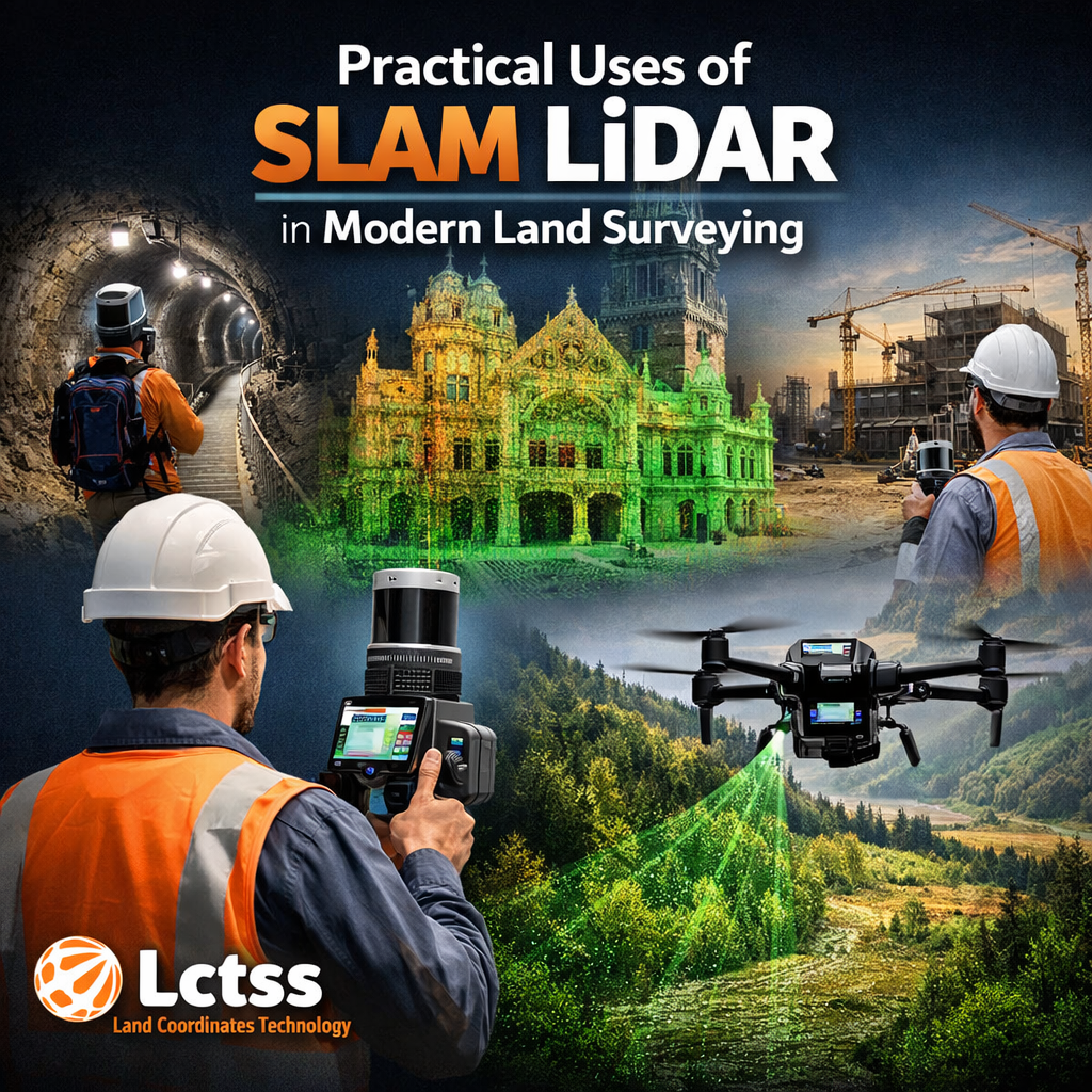
One of the most significant uses of SLAM LiDAR in land surveying is rapid data acquisition. Traditional survey methods often require multiple setups, control points, and extended field time. SLAM LiDAR systems, however, allow surveyors to walk through a site with handheld or backpack-mounted scanners, capturing millions of data points in minutes. This efficiency is especially valuable for large land parcels, infrastructure projects, and time-sensitive surveys. The SLAM LiDAR course at Lctss trains learners to plan surveys effectively, optimize scan paths, and ensure accurate data collection with minimal rework.
Another key application lies in surveying complex and inaccessible environments. Construction sites, industrial plants, tunnels, basements, heritage buildings, and dense vegetation areas pose serious challenges for conventional surveying tools. SLAM LiDAR excels in these conditions by generating detailed 3D point clouds without relying on continuous GPS signals.
Through hands-on training, Lctss teaches surveyors how to handle such challenging projects confidently, making them valuable assets for construction, mining, transportation, and urban development projects.
Accuracy and data richness are also major advantages of SLAM LiDAR technology. While speed is a major benefit, the quality of spatial data is equally impressive. Surveyors trained in SLAM LiDAR can extract contours, cross-sections, volumetric calculations, and as-built documentation from dense point clouds. The Lctss SLAM LiDAR course emphasizes data validation, error correction, and integration with traditional survey control, ensuring professional-grade results suitable for engineering and planning purposes.
SLAM LiDAR is increasingly used for topographic surveys, corridor mapping, and asset documentation. Roads, railways, pipelines, and power lines require detailed spatial information over long distances. SLAM-based mobile mapping systems allow surveyors to capture continuous datasets efficiently. At Lctss, learners are trained to process and interpret this data using industry-standard software, enabling them to deliver actionable insights to engineers, architects, and project managers.
A SLAM LiDAR course is not just about learning how to operate equipment; it is about developing a comprehensive skill set that aligns with future surveying needs. At Land Coordinates Technology, the course focuses on building strong fundamentals in LiDAR principles, SLAM algorithms, sensor calibration, and spatial data accuracy. Surveyors gain a clear understanding of how SLAM systems work and how to apply them effectively in real-world projects.
Practical field training is a core strength of the Lctss SLAM LiDAR course. Learners gain hands-on experience with modern SLAM LiDAR scanners, learning how to plan survey routes, manage data capture, and avoid common errors. This practical exposure helps surveyors build confidence and competence, making them job-ready upon course completion.
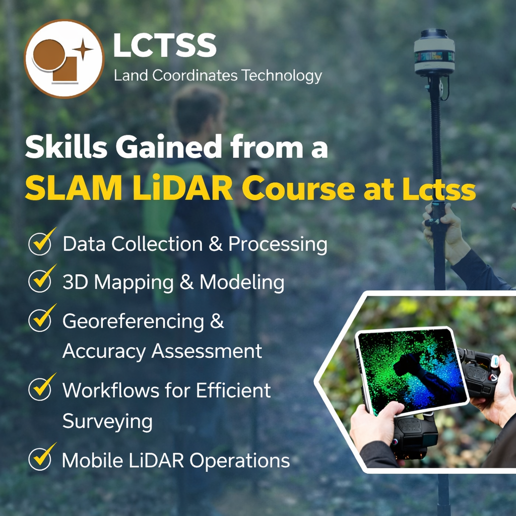
The course also covers integration with GNSS, total stations, and control networks, ensuring surveyors can combine SLAM LiDAR data with traditional methods for maximum accuracy.
Another critical skill developed through the course is data processing and analysis. Raw LiDAR data is only valuable when it is properly processed and interpreted. Lctss provides in-depth training on point cloud processing, filtering, alignment, and export to CAD, GIS, and BIM platforms. Surveyors learn how to create deliverables such as digital terrain models, floor plans, 3D models, and as-built drawings, which are highly demanded across multiple industries.
The SLAM LiDAR course at Lctss also prepares surveyors for future career opportunities. With increasing adoption of digital construction, smart cities, and infrastructure modernization projects, professionals with SLAM LiDAR expertise are in high demand. Surveyors trained in this technology can expand their services, improve project efficiency, and increase their earning potential. The course equips learners with industry-relevant skills that are applicable in land surveying, construction monitoring, urban planning, mining, and geospatial analytics.
By learning SLAM LiDAR at Lctss, surveyors stay ahead of technological trends and position themselves as forward-thinking professionals. The course supports continuous professional growth by combining practical training, real-world applications, and industry insights. As land surveying moves toward automation and digital mapping, SLAM LiDAR skills are no longer optional—they are essential for future surveyors who want to lead rather than follow.