


Table of Contents
ToggleIn today’s fast-growing infrastructure and construction industry, accurate land surveying plays a major role in successful project planning and development. Traditional surveying methods are now being transformed with the help of Artificial Intelligence (AI), drone technology, GIS mapping, DGPS, and LiDAR scanning systems. Lctss (Land Coordinates Technology) provides advanced AI-powered land surveying services designed to deliver highly accurate mapping, faster data collection, and efficient project execution for industries across India.
AI-powered land surveying services combine modern surveying equipment with intelligent data processing systems to improve accuracy and reduce human error. By integrating technologies such as UAV drone surveying, GIS mapping, DGPS surveys, Total Station surveys, and LiDAR scanning, Lctss delivers detailed geospatial information that supports engineering, construction, mining, road development, railway projects, smart city planning, and infrastructure management. These modern surveying solutions help engineers, architects, and planners make better decisions based on precise land data and real-time analysis.
The use of AI in surveying has significantly improved the speed and quality of mapping projects. Traditional survey methods often require large field teams and longer processing times, but AI-based surveying systems automate many tasks such as terrain analysis, feature extraction, contour generation, and data interpretation. This not only saves time but also increases productivity and project efficiency. Lctss uses advanced surveying software and intelligent mapping systems to process survey data with maximum precision, ensuring reliable results for every project.
Modern infrastructure projects require detailed and accurate mapping data before construction begins. AI-powered surveying services from Lctss help clients obtain highly accurate topographic maps, contour maps, boundary surveys, utility mapping, and land development plans using advanced technologies. Drone surveying has become one of the most effective tools for rapid land mapping and aerial data collection. Equipped with high-resolution cameras and AI-based image processing systems, drones can capture detailed site information within a short time, even in difficult terrains.
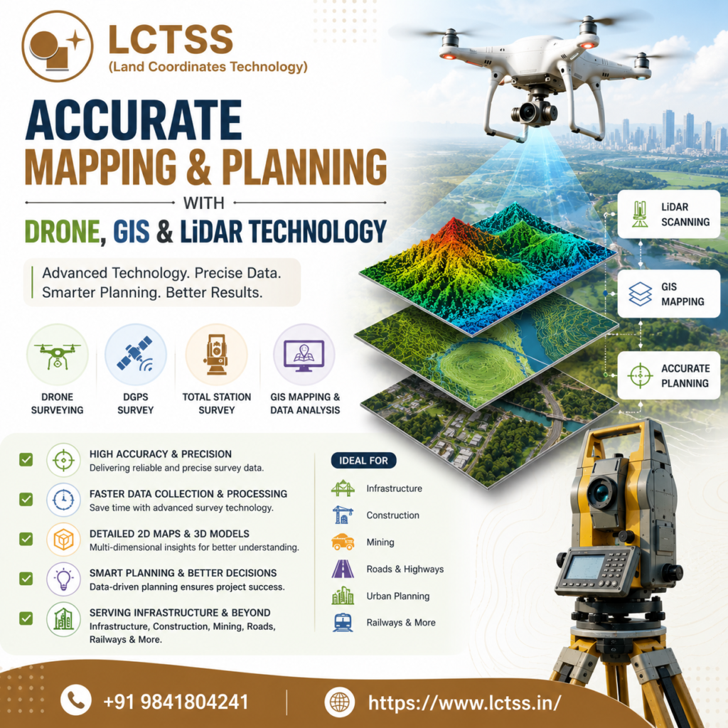
GIS mapping technology further enhances surveying operations by organizing and analyzing spatial data for better planning and management. Geographic Information Systems (GIS) allow project teams to visualize land information, monitor project progress, and improve resource management. Lctss provides professional GIS mapping services that support urban planning, environmental studies, land records management, and infrastructure development projects. The integration of AI with GIS technology enables automated analysis of large datasets, improving the accuracy of mapping outputs and planning strategies.
LiDAR technology is another important advancement in modern land surveying. LiDAR scanning uses laser-based sensors to collect precise elevation and surface data, creating highly detailed 3D models and digital terrain maps. AI algorithms process LiDAR datasets quickly and accurately, helping surveyors identify terrain changes, vegetation coverage, structural features, and land elevations. Lctss uses advanced LiDAR solutions for highway surveys, railway corridor mapping, mining surveys, flood analysis, and smart city projects. These services provide accurate geospatial insights that improve engineering design and reduce project risks.
DGPS and Total Station surveying also remain essential components of professional land surveying services. Differential GPS technology offers highly accurate positioning data that is useful for boundary surveys, control point establishment, and construction layout planning. Total Station instruments provide precise angle and distance measurements for engineering and construction projects. By integrating AI-driven data processing with DGPS and Total Station surveys, Lctss ensures reliable measurements and efficient project execution for clients across various industries.
AI-powered land surveying services offer several advantages compared to conventional surveying methods. One of the biggest benefits is improved accuracy. AI systems can process large amounts of geospatial data quickly while minimizing human errors. This helps engineers and project managers make confident decisions based on accurate land information. High-precision mapping also reduces costly mistakes during construction and infrastructure development.
Another major advantage is faster project completion. AI-based surveying workflows automate data processing, feature extraction, and map generation, significantly reducing the time required for survey analysis. Drone surveying and LiDAR scanning can cover large areas within hours instead of days, allowing projects to move forward more efficiently. Lctss focuses on delivering timely and accurate survey reports to support faster decision-making and project planning.
Cost-effectiveness is another important benefit of AI-powered surveying solutions. Modern surveying technologies reduce the need for large manpower and repetitive fieldwork, helping organizations save operational costs. Accurate data collection also minimizes rework and construction delays, resulting in better project management and resource utilization. Lctss provides affordable and efficient land surveying services that meet the needs of government projects, private infrastructure companies, engineering consultants, and construction firms.
Safety and accessibility are also improved with AI-driven surveying methods. Drone surveys can safely collect data in hazardous or difficult-to-reach areas such as mining zones, highways, forests, and elevated terrains. AI systems can analyze remote survey data without requiring continuous field presence, reducing risks for survey teams. This makes modern surveying technologies highly suitable for complex infrastructure and industrial projects.
Lctss (Land Coordinates Technology) is committed to delivering high-quality land surveying and GIS mapping services using the latest technologies and industry standards. The company combines technical expertise with advanced survey equipment to provide reliable and accurate geospatial solutions for modern infrastructure development. With strong experience in AI-powered surveying, drone mapping, LiDAR scanning, DGPS surveys, GIS analysis, and Total Station surveying, Lctss supports projects of all sizes with precision and professionalism.
The company focuses on innovation, accuracy, and client satisfaction by using advanced software and intelligent data processing systems for every survey project. Whether it is road alignment planning, land acquisition surveys, topographic mapping, utility corridor surveys, or urban infrastructure development, Lctss ensures accurate mapping results that help clients achieve successful project outcomes.
As industries continue to adopt digital transformation and smart infrastructure technologies, AI-powered land surveying services are becoming essential for efficient planning and development. Modern geospatial solutions improve productivity, reduce project risks, and provide valuable insights for long-term infrastructure management. Lctss remains at the forefront of this technological advancement by offering reliable, accurate, and cost-effective land surveying services powered by AI, GIS, drones, LiDAR, DGPS, and modern surveying systems.
Businesses, engineers, construction companies, and government organizations looking for advanced mapping and planning solutions can rely on Lctss for professional land surveying services tailored to their project requirements. Through innovation and technology-driven solutions, Lctss continues to support the future of smart surveying and accurate infrastructure planning in India.