


Table of Contents
ToggleIn today’s rapidly developing infrastructure and construction industry, the demand for skilled land surveyors is growing significantly. Modern engineering projects require highly accurate surveying methods, and this has increased the importance of advanced surveying technologies such as DGPS, GIS mapping, Total Station surveying, drone surveying, and LiDAR technology. To meet these industry demands, Lctss (Land Coordinates Technology) offers a Professional DGPS Survey Training Course with Modern Survey Equipment designed to provide students and professionals with practical knowledge and industry-oriented skills.
The Professional DGPS Survey Training Course at Lctss focuses on real-time field applications and modern surveying techniques used in civil engineering, land development, highway projects, railway surveys, mining, GIS mapping, and infrastructure planning. DGPS (Differential Global Positioning System) technology is widely used for high-precision land surveying because it delivers accurate positioning data and improves survey efficiency. With increasing use of digital survey methods, learning DGPS surveying has become an essential skill for aspiring surveyors and civil engineering professionals.
Lctss provides practical training using advanced survey equipment and modern technologies to ensure students gain hands-on experience in real project environments. The training program is designed by experienced industry professionals who understand current market requirements and the latest surveying trends. Students are trained on modern DGPS instruments, Total Stations, GPS devices, GIS software, drone surveying tools, and data processing applications that are commonly used in today’s surveying industry.
One of the major advantages of joining the DGPS Survey Training Course at Lctss is the strong focus on practical learning. Instead of only theoretical classroom sessions, students participate in live field surveys and practical projects that help them understand real-time surveying challenges and solutions.
The course includes detailed training on coordinate systems, topographic surveys, contour mapping, land measurements, route alignment surveys, and data collection methods using advanced DGPS equipment.
Modern surveying industries require professionals who can efficiently handle digital survey instruments and geospatial technologies. Lctss ensures that students receive comprehensive knowledge of survey data collection, processing, analysis, and reporting.
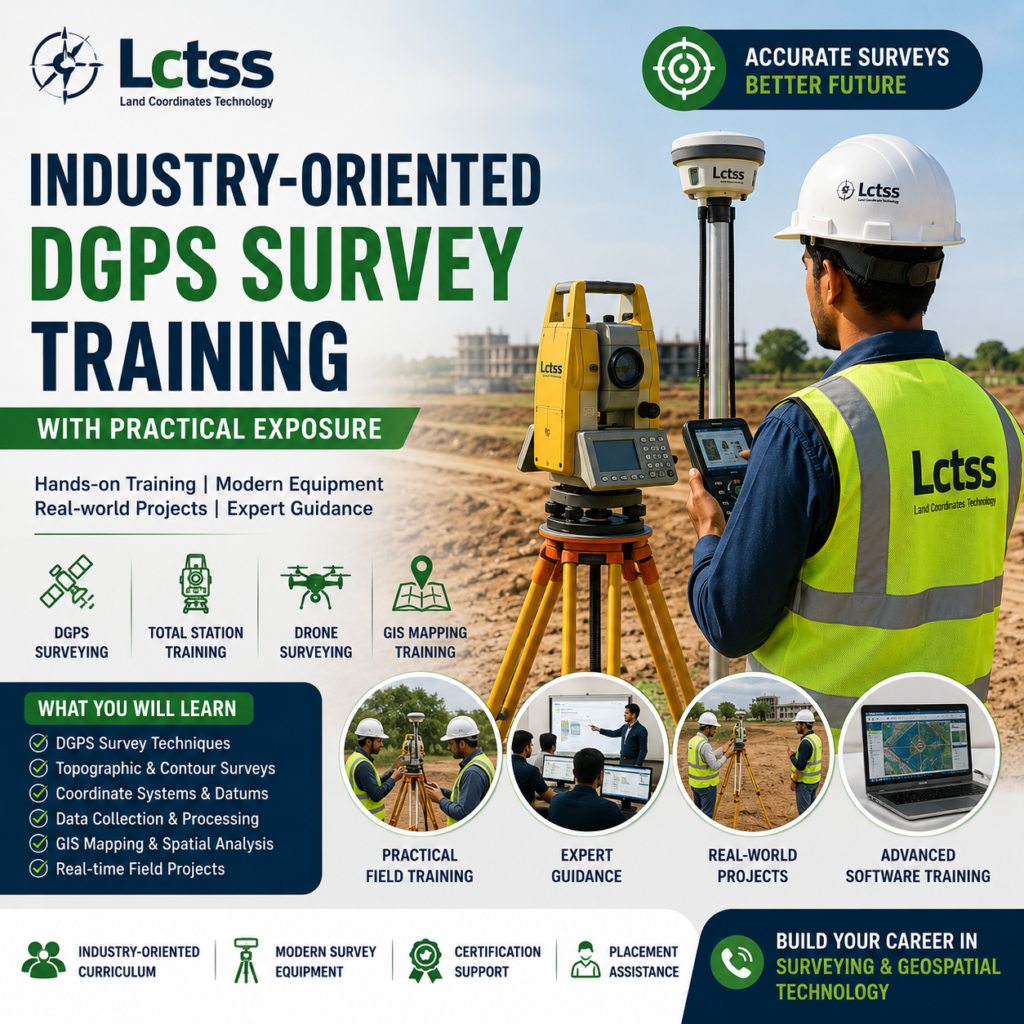
The course includes detailed training on coordinate systems, topographic surveys, contour mapping, land measurements, route alignment surveys, and data collection methods using advanced DGPS equipment.
The course also covers GIS mapping techniques, which are essential for urban planning, infrastructure development, utility mapping, and smart city projects. By learning both DGPS surveying and GIS technologies together, students gain valuable technical skills that improve their career opportunities in the geospatial and civil engineering sectors.
The training curriculum is continuously updated to match the latest industry standards and technological advancements. Students learn how modern survey equipment improves accuracy, reduces human errors, and increases productivity in construction and engineering projects. Through practical exposure and fieldwork training, participants gain confidence in operating advanced survey instruments independently and professionally.
The surveying industry has evolved rapidly with the introduction of modern technologies such as DGPS, drone surveying, LiDAR scanning, and GIS mapping systems. Lctss integrates these advanced technologies into its Professional DGPS Survey Training Course to provide students with future-ready skills. The course emphasizes the importance of digital surveying methods that are widely used in large-scale infrastructure and development projects.
Students are trained to use modern DGPS equipment for accurate positioning and mapping applications. They also gain knowledge of Total Station instruments for angle and distance measurements used in construction layout and land surveys. In addition, the course introduces participants to drone surveying technologies, which have become highly popular for aerial mapping, terrain modeling, and site inspections. Drone-based surveys help collect large amounts of survey data quickly and accurately, making them valuable for industries such as mining, agriculture, transportation, and urban development.
GIS mapping is another important component of the training program at Lctss. GIS technology helps professionals analyze, manage, and visualize geographic data for better decision-making in engineering and planning projects. By combining DGPS data with GIS mapping applications, surveyors can create highly accurate digital maps and spatial databases for various industrial applications.
Lctss also provides training in survey data processing and report generation using modern software tools. Students learn how to interpret survey data, generate maps, prepare technical reports, and maintain project documentation according to professional standards. These skills are highly important for working in surveying companies, engineering consultancies, government departments, and infrastructure organizations.
The demand for skilled DGPS surveyors and geospatial professionals is increasing across multiple industries. Infrastructure development, highway construction, railway projects, smart cities, mining operations, agriculture, and environmental planning all require accurate land surveying services. By completing the Professional DGPS Survey Training Course at Lctss, students can explore a wide range of career opportunities in both public and private sectors.
Professional surveyors with DGPS and GIS skills are highly valued because they can provide accurate survey data for planning and construction activities. Companies involved in civil engineering, land development, utility mapping, and transportation projects require trained survey professionals who can handle modern survey equipment efficiently. The course at Lctss helps students develop practical expertise that improves their employability and professional growth.
Fresh graduates, diploma holders, civil engineers, and working professionals can all benefit from this advanced training program. The course is suitable for anyone interested in building a career in land surveying, geospatial technology, GIS mapping, and infrastructure development. Lctss aims to provide quality training that prepares students for real industry requirements and enhances their technical capabilities.
With expert faculty guidance, practical field exposure, and access to advanced survey equipment, Lctss has become a trusted name in professional surveying education and training. The company focuses on skill development, technical excellence, and industry-oriented learning methods to help students achieve successful careers in the surveying and geospatial sectors.
As modern construction and infrastructure projects continue to expand, the importance of accurate land surveying and digital mapping technologies will continue to grow. Learning DGPS surveying with modern equipment and advanced geospatial technologies can open the door to excellent career opportunities in India and abroad. Lctss (Land Coordinates Technology) remains committed to delivering professional training programs that equip students with the knowledge, confidence, and practical skills needed to succeed in the modern surveying industry.