


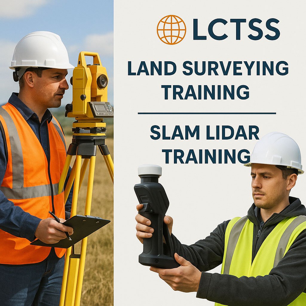
In today’s fast-evolving geospatial industry, high-quality Land Surveying Training and SLAM LiDAR Training are critical to building a strong workforce ready to tackle real-world challenges. Lctss (Land Coordinates Technology) stands at the forefront, offering comprehensive, industry-driven courses that empower surveyors, engineers, GIS professionals, and technicians with the skills they need to succeed.
Whether you’re starting your career or looking to upgrade your expertise, Lctss provides the tools, techniques, and practical exposure necessary to excel in the competitive field of land surveying and 3D mapping.
Table of Contents
ToggleLand surveying is the foundation of construction, engineering, and mapping projects. Precise measurements, boundary establishment, topographical studies, and infrastructure design all depend on accurate surveys. Proper Land Surveying Training ensures professionals can:
Use traditional and modern surveying equipment
Understand legal aspects of property boundaries
Apply geospatial technologies like GPS, Total Stations, and drones
Produce high-quality survey reports and maps
At Lctss, our Land Surveying Training program covers theoretical knowledge and intensive practical sessions to bridge the gap between classroom learning and real-world application.
SLAM (Simultaneous Localization and Mapping) LiDAR is a revolutionary technology that allows real-time 3D mapping without the need for GPS signals. It is widely used in industries like construction, mining, forestry, urban planning, and autonomous navigation.
Our SLAM LiDAR Training at Lctss focuses on:
Principles of SLAM technology
Operation of handheld and drone-mounted LiDAR systems
Processing and analyzing LiDAR point cloud data
Real-world applications and project-based learning
We ensure trainees can confidently use cutting-edge SLAM devices and software, enhancing their value in the geospatial marketplace.
Course Modules:
Fundamentals of Land Surveying
Topographic Surveys
Construction and Engineering Surveys
GPS and GNSS Surveying
Drone Surveys and Photogrammetry
Legal Aspects and Surveying Ethics
Data Management and Reporting
Key Features:
Hands-on training with Total Stations, GNSS, drones, and software like AutoCAD and Civil 3D
On-field projects for real-world experience
Expert trainers with decades of industry experience
Certification recognized across major surveying companies and government agencies
Course Modules:
Introduction to LiDAR Technology
Fundamentals of SLAM Algorithms
Operation of SLAM Devices (e.g., handheld, mobile, UAV-based)
Point Cloud Data Processing (Filtering, Classification, Exporting)
Software Training (e.g., GeoSLAM Hub, Trimble RealWorks, CloudCompare)
Applications in Construction, Mining, Urban Mapping, and more
Key Features:
Practical training sessions with state-of-the-art SLAM devices
Case studies and industry-specific use cases
Data processing exercises to create deliverables like 3D models and floor plans
Career guidance and professional certification upon completion
Industry-Relevant Curriculum: Designed by professionals, updated with latest technological trends
Modern Equipment: Access to GNSS systems, Total Stations, drones, and SLAM LiDAR
Flexible Learning: On-campus, online, and hybrid training options
Placement Support: Assistance with internships and job opportunities post-training
Affordable Fees: High-quality training at competitive rates
After completing Land Surveying Training and SLAM LiDAR Training at Lctss, students can pursue careers such as:
Land Surveyor
GIS Technician
Drone Survey Specialist
SLAM LiDAR Operator
Geospatial Analyst
Construction Project Surveyor
Urban Planner
Environmental Survey Specialist
Top construction companies, engineering consultancies, government departments, and research organizations highly value Lctss-trained professionals.
Anyone interested in a career in land surveying, civil engineering, GIS, or construction — whether beginner or experienced — can benefit from this training.
You will get hands-on experience with Total Stations, GNSS/GPS systems, drones (UAVs), and essential surveying software like AutoCAD and Civil 3D.
Our standard program spans 6 to 8 weeks, including both theory and fieldwork sessions. Fast-track options are available.
No. While surveying knowledge is helpful, our SLAM LiDAR Training is structured to accommodate both beginners and professionals.
We train on popular devices like GeoSLAM ZEB Revo, ZEB Horizon, and other handheld or UAV-mounted LiDAR systems.
SLAM LiDAR is widely used in construction, mining, forestry, archaeology, urban mapping, and autonomous vehicle navigation.
Yes! Upon successful completion of either or both programs, you will receive an industry-recognized certificate from Lctss.
While placements are not guaranteed, Lctss provides strong support through job alerts, recommendations, resume preparation, and interview coaching.
Yes, we offer online modules, especially for theory sessions. Practical sessions are conducted at our designated training centers.
Simply visit our official website, fill out the enrollment form, or contact our admissions team. We offer batch intakes throughout the year!
Lctss (Land Coordinates Technology) is your trusted partner in building a successful career in the geospatial industry. Our Land Surveying Training and SLAM LiDAR Training programs are meticulously crafted to meet the demands of modern surveying and mapping practices.
By choosing Lctss, you invest in world-class education, expert guidance, and real-world skills that open doors to numerous career opportunities. Whether you’re mapping cityscapes or helping design tomorrow’s infrastructure, your journey starts with Lctss!